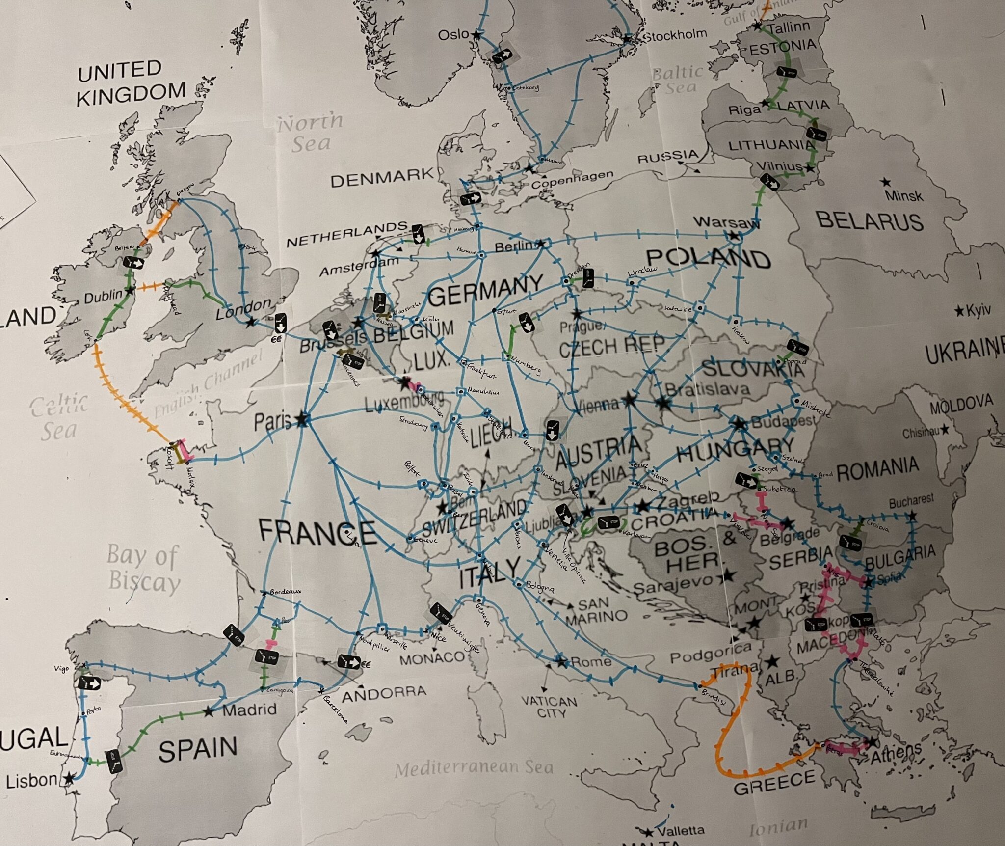
In mid December 2023 I was working on a documentary with a Dutch film crew and the producer asked me “Jon, did you ever think of making a board game to explain the problems with international rail in Europe?” I had not ever thought of that, but then my mind started to work, and I started to design boards… and so now there is a prototype of a #CrossBorderRail board game. The idea is to explain the problems of international rail in Europe from a passenger point of view – and make it fun as well.
The idea is that 2-6 players (works better with 3 or more) start somewhere at the edge of Europe, and have to race to Bruxelles, and have to pass 5 border crossings en route. As they do so, some things happen (Incidents) and players need some special permissions or other types of transport in order to proceed in the places where the trains do not run.
All of the files to print out your own version of the game are on Nextcloud here – USE THESE FILES AT YOUR OWN RISK. Here you can find the game rules, printing instructions, and a PDF file of the current version of the board for the game.
The basis of the map uses Tennessine’s Metro Mapper – you can find the map I am developing here.
At the moment this is just a prototype. If it does work I might then improve the design and sell versions of the game. If you do test it I would then very much welcome your feedback on what you think of it!
Version
Files are currently version 1.2.0, correct as of 3 January 2024. Some errors were found in both the map and incident cards in V 1.1.0 and have been corrected. More work has been done to prevent players getting stuck in corners of the board – more ferry routes, and some additional trains in the Baltic states have been added to overcome these issues. More A icons have also been added to the board. Rules have been adjusted regarding how extra Action Cards can be drawn by players.
FAQ
Will this game be available for sale?
Maybe – it depends how well the prototype works.
Why is the map not geographically accurate?
I wanted to make the game reasonably accurate for the rail aspect as possible – the number of hours a trip takes is determined by the marks on the lines, 1 mark per hour. This means that the parts of Europe where train travel is slower, or lines more dense, are rather over-represented. If the game play works I might in the future re-design the map to be a bit more geographically accurate.
Why is [this national line] missing?
This game is about international rail. So many national lines are missing. I am not going to add national lines for the sake of it. Some national lines are included if stations along them are somehow mentioned in an Incident Card.
Why is this [international line] missing?
There are more than 400 current and former international rail lines in Europe – I have mapped them all here, and have visited almost 200 of them so far. This game covers only a small number of these lines, and 30 are featured in the Border Cards in the game. I am open to adding a few more, but the only ones I will add need to be in places that contribute in addition to the educational value of the game.
Why is some bus / ferry / bike route missing?
The game is about railways. Bike, bus and ferry routes have only been added to complement rail routes. If you think an additional route for one of these modes is needed, please let me know. But I am not going to add those for the sake of it.
Why is the map so complicated?
This is already a rather simplified version of Europe’s railway map. Should I really simplify it more? If so please tell me which lines to remove.
I have tested the game, and I see a way to improve it. How can I contribute?
Please send me an email via this form first of all, explaining your idea or proposal.
I disagree with an assumption you make in the game. How can I get you to change it?
That might be rather hard, as my positions about some of the issues covered in the game are rather fixed! But by all means let me know and I will have a go at incorporating your view. Or download the materials, and make your own version!
I want the files in some other format!
ODT, DOCX and PDF files are available. That ought to be enough for now.
Images